Sunday, March 28, 2010

Bloor West Village

The Heritage of Bloor West Village

Between 1838 and 1855 Lieutenant Colonel William Smith Durie, an officer from Gibraltar, lived in Thornhill, Barrie and Toronto. His Toronto Estate was the area that today we call Bloor West Village. Durie Street once was a path going through his property. He died in 1885 after a long and successful career in the militia.

Another famous resident in the early days of Bloor West Village was John Scarlett, a businessman who owned a fairly large chunk of land in the area, north of Bloor Street and west of Keele Street. A horse lover, he opened a racetrack in 1837 on his property which stayed open for four years. In 1838, he built his house at the corner of Dundas and Keele and named it Runnymede.

Laying track at Dundas and Keele streets in 1912. Photo credits: Archives Toronto

Both men saw the area changing in the 1840’s when the railway came. With the arrival of the trains, landowners started to divvy up their properties and offer them for sale. One of the first settlers to do so was John Scarlett, who subdivided his land and called it “Runnymede Estate”.

Twenty-four years after the death of Lieutenant Durie in 1909, what was his property became annexed to the expanding City of Toronto. The new district grew fast with improvements and following after the annexation, city services were implemented. The first residents to benefit from this fast wave of new services were immigrants of Eastern European background.

Navigating the Area

The limits of Bloor West Village are bound by Runnymede Road to the East – Bloor Street West to the south – Annette Street to the north – Jane Street to the west. Although some maps also include other zones within the Bloor West district. As such, these expanded areas are sometimes referred to as “Runnymede Bloor West Village” or “High Park North”. Bloor West Village residents enjoy the presence of two nearby subway stations, Jane and Runnymede which are both situated very close to the residential streets. The Annette Street bus transports passengers through the area, and subsequently travels to the Dupont subway Station on the Yonge-University-Spadina subway line.

The Gardiner Expressway and the Lake Shore Boulevard are just a couple minutes away, and one can drive downtown in less then half an hour (when there is no traffic of course!).
Many people frequent Bloor and Annette Streets for the many local shops and restaurants. It is also not uncommon for residents from other parts of the city to visit the neighbourhood to do some shopping, and of course enjoy the many bakeries, cafes and delicatessins.

Attractions

Bloor West Village has a very popular shopping district, located along Bloor Street between Jane Street and Ellis Park Road. The district encompasses more than 400 boutiques, coffee shops, restaurant and other services – most of it being “healthy oriented”. The BIA (Business Improvement Association), created in 1970, created the first shopping district in the world which promotes shopping. The association also brings life to the area by holding events and several festivals. One of the most popular events is the Ukrainian Festival, the largest Ukrainian street festival in North America!

Small businesses are sharing Bloor West with large corporations. Photo credits: Proliphic

One of the most famous stores in the neighbourhood is the Chapters, which took over the Runnymede Theatre in 1999. Commonly known as the “Runny”, this grand vaudeville theatre was converted to show movies in the late 1930s. But even with all these changes over the decades, the building kept its majestic feeling, with an auditorium ceiling painted to give the illusion of an open sky. The rest of the interior is themed to give visitors the impression of an exotic place. It is said that the store is haunted by the ghost of a little girl whose death was caused by a falling sandbag. In fact, there is no official record of anybody dying there – people can shop for books in peace!

Inside the Chapters Bookstore. Photo credits: Cinemarie

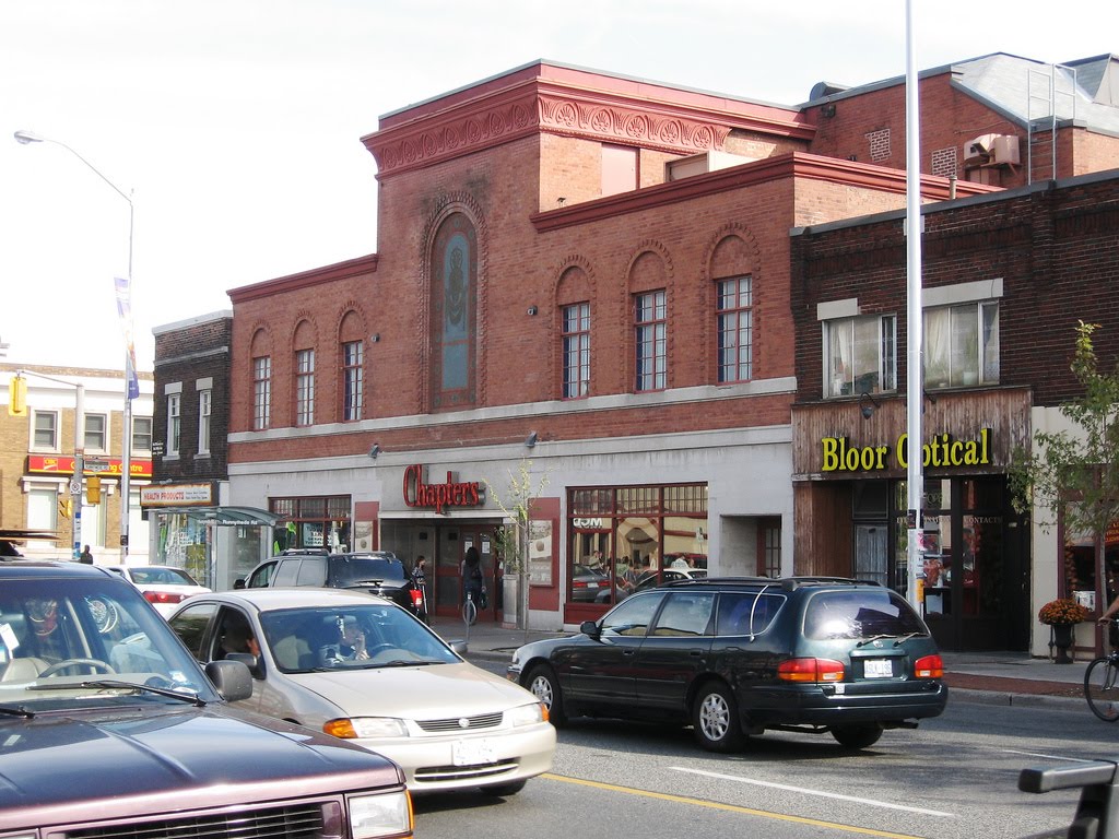
Exterior view of the Chapters Bookstore. Photo credits: Mdanyluk

Many Torontonians move to this prime location for its proximity to High Park, which is the largest mixed recreational and natural park in Toronto. Spanning on 161 hectares (398 acres or 1.61 km2), the urban green space offers many sporting – cultural – educational facilities. It is also a great place for dog owners, since the park allows dog walking on-leash. For those who prefer green space by the lake, there is the Humber Bay Park, just south of Bloor West Village. Located in Etobicoke by the Lakeshore Boulevard, the park has welcomed visitors officially since 1984.

Colborne Lodge is the 19th century home of High Park founders, John and Jemima Howard. In 1873, the Howards deeded their 165 acre country property to the City of Toronto to be used as a public park. Photo credits: Suzanne Williams

Architecture

Even though the neighbourhood’s roots date back to the 19th century, most of the residential streets were developed between 1910-1930. Many of the homes built consist of 2 level duplexes designed in the American Craftsman style, featuring wood trim, oak accents, hardwood floors, fireplaces (if you are lucky!), and the very iconic Toronto front porch beneath an extension of the main roof. Some pockets are starting to see some of the older homes being torn down to make way to bigger new constructions.

Some examples of other architectural styles in Bloor West Village include Victorian, Edwardian and Tudor. The brick houses, similar to the American Craftsman houses, offer two-storey / four-bedroom features.

But no matter what style you may see on these streets, the neighborhood is a favorite for its well established houses, shaded by the majestic Oak and Maple trees.

Monday, March 22, 2010

The Annex / South Annex

The Heritage of The Annex / South Annex

The first use of the word “Annex” was by a land developer named Simeon Janes. In 1886, he owned a good portion of the land between Bedford and Spadina – Dupont and Bloor. His property was not part of the Toronto District at the time, and when he applied to the City Council to have his new divided parcel taken by the city, his residents started to use the term “The Toronto Annex” when speaking of his land. Two years later, some other lands were annexed to Janes’ property adding to the area Torontonians were already calling “the Annex”.

Simeon Janes used huge profits from his 1880s upscale neighbourhood to build a decadent mansion on Avenue Road. This house, named Benvenuto Place was purchased and demolished in 1927. Photo credits: Toronto Archives

The area quickly became one of the Toronto’s elite neighbourhoods. Businessman George Gooderham, of the Gooderham and Worts Distillery, was one of the first residents of the fashionable Annex. We could find on these streets the best houses, decorated with the latest trends and some outrageous interiors too! Timothy Eaton’s wife had the Eaton Mansion decorated in a style that made the entire city talk!

George Gooderham residence, located at the northeast corner of St.George and Bloor streets, still stands today. Photo credits: Toronto Archives

Stemming from the popularity of the Annex, nearby land owners were claiming to be a part of the area. This area, housing the University of Toronto, coined itself “South Annex”. The presence of the U of T propelled the area to the list of the most expensive neighbourhoods in the city.

Thimothy Eaton, one of the most famous resident of the golden years of the Annex. Circa 1890. Photo credits: Toronto Public Library

The golden years of the area ended somewhere in the 1920’s, when the rich upper class started moving into new hip north communities such as Lawrence Park and Forest Hill. However, some of the original families stayed and lived with the new middle class that started to find homes on the Annex streets. It’s these people who lobbied to stop the “Spadina Expressway”, a large highway project that would have split and destroyed the Annex as we know it today.

A rendering of the "rejected" Spadina Expressway, at Spadina and Davenport. We can see the famous Casa Loma in the middle... Photo credits: Toronto Archives

Navigating the Area

The limits of the Annex / South Annex (including the Yorkville area) nowadays are bound by Yonge Street to the East – College Avenue to the south – CPR railroad tracks to the north – Bathurst Street to the west. Although some people do like to say that the Annex stretches all the way to Christie, this area between Bathurst and Christie is actually Seaton.

The best way to get around the Annex is by foot with many shops, restaurants and grocery stores at your doorstep. With many of the university set residing in the area, cycling is also a popular mode of transportation. While Bloor Street is the main thoroughfare, one can find dedicated bike lanes on the less travelled Harbord Street.

There are many small independant grocery store in the Annex. Photo credits: M.V. Jantzen

The Annex is also one of the best served neighbourhoods by the Subway and TTC. The University-Spadina line runs to Dupont, Spadina and St-George Stations. The Bloor-Danforth line runs east-west under Bloor Street with stops at St. George, Spadina and Bathurst Stations.

Attractions

During the 1960’s, many artists made the Annex their home. Writers, poets, actors and musicians became regular customers at various “hangouts”. Some famous people are still living in the Annex, such as Margaret Atwood and former Governor General Adrienne Clarkson.
The focal point of the Annex is Bloor Street West, where it became vibrant with unique stores and upscale restaurants. The selection here is very eclectic, going from the original Hungarian stores all the way to the fine cuisine restaurants. For those who like to spend some time at a local pub, the area has a couple, such as the Brunswick House and the hugely popular Madison Pub.

The Brunswick House Pub, on Bloor Streeet West.Photo credits: Gbalogh

Of course, the proximity of the University is attracting a very creative artsy community who enjoy the many affordable dining venues, bookshops, theatres and the ROM. The Tarragon Theatre is celebrating over 38 seasons and 170 new works premiered.

Architecture

The “Annex look” finds it’s roots in the work of architect Edward James Lennox who was better known as the man behind the Old City Hall and Casa Loma. His work established the Richardsonian Romanesque and Queen Anne styles as the most wanted designs of the area. He designed three houses in the neighbourhood. Two Hundred Eighty Bloor Street West is now demolished. Thirty Seven Madison Avenue currently in it’s original state and Two Thirty Four St. George Street serves as the front façade of an apartment complex.


The Arthur R. Boswell House (1895, 1900), 69-71 Spadina Road.
Photo credits: John Fitzgerald

Of the few houses inspired by the Richardsonian architecture, the York Club is probably the most impressive. Formerly the Gooderham’s house, it was sold in 1909 and became the quarters of the then Nascent Club. Situated at the corner of St. George and Bloor Street, the house features an harmonious stone and brick façade, gables and a corner tower with bowed windows.

The St. George St. elevation of the George Gooderham house (1892, David Roberts Jr.).
Now the York Club. Photo credits: John Fitzgerald

Extensive use of shingles, terracotta brick details, uniquely ornate porches and eccentric roof décors can be seen throughout the area. Some of the oldest houses, built during the time of Yorkville Village, exemplify historical elements such as charming carriageways and gables.

The neighbourhood today: a mix of old and new. Photo credits: John Fitzgerald

The dicotomy of the architecture in the area is prevelant if one were to consider the 1960’s Uno Prii design. Prii was an architect from Estonia who studied in Stockholm before emigrating to Canada in 1950. He changed the landscape of the neighbourhood by designing a half dozen apartment buildings featuring modern swooping curved balconies, circle & whimsy details and all-white façades. Other architects followed the Prii’s new wave and built interesting and handsome buildings in the Late Modern Look.

A characteristic work of Uno Prii's, although the balconies have been much altered.
Opened in 1969. Photo credits: John Fitzgerald

Friday, March 19, 2010

Rosedale

The Heritage of Rosedale

In 1827 Sheriff William Botsford Jarvis married Mary Boyles Powell and they moved to the rustic suburbs of the city. By the late 1830s a wonderful estate had emerged with the influence of local architect John Howard. The abundance of beautiful wild roses growing on their land prompted Mary to name their home “Rosedale”.

During the 1830s many families followed the Jarvis clan and bought lots in what is now Rosedale. Shortly thereafter the Jarvis’ enjoyed an influx of neighbours. Joseph Bloor, Joseph Price and Sir D.L. Macpherson are among the wealthy that moved into the area. With the proximity of the brick and tile yards (the area now known as Ramsden Park), more affluent people began to build their homes in Rosedale. Two years after Mary died, Jarvis, who could not reside at Rosedale House anymore, sold a portion of his farmland and divided the villa into two dwellings. The suburb became known as Rose-Park shortly thereafter. By 1854, a first subdivision plan was proposed to Toronto.

Sir D.L. Macpherson in 1865, one of the early resident of Rosedale. Photo credits: Musée National des Beaux-Arts du Québec

The original farmlands and estates were subdivided many times and sold to the elite of Toronto. By 1884 forty two lots were occupied by bankers, senators, businessmen, architects and well to do friends of other lot owners in Rosedale. The rush of the upper-class society is probably the reason the number had swelled to 100 by 1890.

The Fourth Government House in Rosedale, demolished in 1961 to create the Chorley Park. Photo credits: Toronto Archives

Today, the footprint of Rosedale is not that different from the original Castle Frank. The streets are well defined by the presence of the two ravines which meet at Castle Frank. The neighbourhood is now approximately 450 acres and includes about 2,500 houses.

Sir Edward Kemp, a Conservative MP and militia minister during World War I, built a second, 24-room Castle Frank, which was knocked down in 1962 to make way for the present Rosedale Heights Secondary School. Photo Credits: Toronto Archives

Navigating the area

The boundaries of Rosedale are Yonge Street to the west – Bloor Street East to the south – CPR railroad tracks to the north – Bayview Avenue and Moore Park Ravine to the east.
The natural topography, which imposes a very organic street maze, is considered by many to be one of Rosedale’s best assets and is great for walking around. With all its dead ends and winding streets, the topography of the area translates into Rosedale being one of the safest neighbourhoods in central Toronto.

T.T.C. Bus # 13 (Fifth Ave Coach Co.) in 1923. Photo credits: Toronto Archives

Newcomers and well established residents appreciate the convenience of being so close to downtown. For those who use public transit, the neighbourhood is served by three subway stations. The aptly named Rosedale station on the Yonge line, situated at the corner of Yonge and Crescent Road – and the Sherbourne and Castle Frank stations on the Bloor-Danforth line located on the south eastern portion of the area. Bus 82 runs from the Rosedale Station and terminates just north of Rosedale. Bus 75 runs to the eastern end and can be caught at the Sherbourne Street Station.

Attractions

The Rosedale Valley is an expansive green space that separates Rosedale from Yorkville, designating the area the green oasis of Toronto. From the north side, Torontonians can enjoy the breathtaking views of skyscrapers which give way to steep tree-filled slopes. The best view is from the bridge where Sherborne Street crosses the valley on Sherbourne.
Ramsden Park, located on the western boundary of the area, offers a more “urban flavour”. Very pleasant in every season, it is possible to have a nice picnic, play tennis on one of the courts, or skate on the rink during the winter.

Many mature trees in Ramsden Park, for the visitors to enjoy! Photo credits: Viviloob

Yonge Street in Rosedale is truly mouth watering. Many bakeries and restaurants offer their patrons a genuine piece of Paris, without any pretentiousness. Patachou Patisserie, at 1120 Yonge, is a great place to buy a variety of delicate desserts and pastries. For those who prefer big portions and honest cuisine, the Rosedale Dinner is the perfect solution. Not situated on Yonge, but still worth mentioning, is the Cobs Bread, located on Bloor Street East. A visit here will put anyone in a good mood!

Architecture

The original country houses in Rosedale were built between 1850 and 1880, of the Italianate style. One of the last examples of that era is the house at 54 South Drive, residence of Mr. Thom, built in 1881.

54 South Drive. The house features arched second floor window, polychromatic masonry (contrasting colours in bricks), rooftop lantern, and a patterned slate roof. Photo credits: Ettml

Rosedale is a telling witness of the diverse Victorian era melting pot. Through the decades, styles were introduce and discarded in the neighbourhood. The most popular styles included the Second Empire, Queen Anne, Richardsonian Romanesque, and Colonial Revival. The streets of Rosedale are rich with houses for each of these styles. By the end of the 19th century, the architectural confusion died down and the Neo-Tudor and Neo-Georgian became the most wanted styles in the area. With time, newer houses built after 1910 became more informal.

The 1950s and 1960s saw a wave of people leaving the urban centre to establish themselves in the “safer” and more modern, emerging suburban neighbourhoods. The big mansions in Rosedale were outdated and too expensive to maintain. Many homes were converted into rooming houses, while others were torn down to make way for low-rise apartment buildings. But for some miraculous reason, the area was not completely levelled and many of the original homes still remain today.

1 May Square is designed in the spirit of architect Lennox, circa 1890. Photo credits: Scott Weir

At the corner of South Drive and May Square. Photo credits: Scott Weir

Nowadays, most of the apartment buildings have been converted into condominiums. Older houses are being turned back to single family residences and new townhouses are being built. The area might have lost the maids and the butlers, but residents enjoy other forms of luxury, like updated interiors and state of the art security systems.


Detail of 86 South Drive, built in 1888. Photo credits: Scott Weir

Tuesday, March 16, 2010

Cabbagetown

The Heritage of Cabbagetown

Much has been said about Cabbagetown and its history. It is one of the most famous neighbourhoods in Toronto and it is known today as “the largest continuous area of preserved Victorian housing in North America”.

Winchester Bridge, circa 1870.

In the early 1840s, this area was known as “the village of Don Vale” which had developed around Winchester Bridge Street. Back then many travellers enjoyed the village’s taverns and hotels. Decades before the construction of the Prince Edward Viaduct, the old Winchester Bridge was the only way to cross the Don River in the north.

Winchester cottages, fine exemples of brick houses in Cabbagetown. Photo credits: Scott Weir

The name “Cabbagetown” was inspired by the Irish immigrants who lived there in the late 1840’s. It is said that they were so poor, they had to grow cabbage patches in their front yards. By the end of the 19th century, these families were well established in Cabbagetown. Most of them were employed in the industries in Corktown. It’s this middle-class that built the brick Victorian style houses in the area.

335-337 Parliament Street, expropriated for Regent Park North, 1947. Photo credits: Toronto Archives

Sadly, the original lower portion of Cabbagetown, now known as Regent Park, slowly became Toronto’s largest slum. In the 1940s, the City razed southern Cabbagetown to make way for the Regent Park housing project. The remaining northern neighbourhood was also to be cleared for a similar project. Fortunately, a man named Karl Jaffary, started a protest to protect the old Don Vale from the bulldozers. He was successful in his battle and by 1969 became one of the city councillors who formed a movement to stop such plans in Toronto.

Not until the 1970s did the area start to gentrify. Wealthier residents were buying the elegant grand Victorian houses and restoring them to their original beauty. Many of the residents who bought during that time period still live there.

Navigating the Area

Today’s true limits of Cabbagetown (after the demolition of part of the original neighbourhood, which is now called Regent Park) are bound by the Don River to the east – Gerrard Street to the south – St. James Cemetery to the north – Sherbourne Street to the west. Some residents of the area would argue that the western limit is Parliament Street. However, the survival of incredible Victorian houses between Parliament and Sherbourne has extended the original footprint of Cabbagetown to the west. Interestingly enough, the original boundaries, before the government housing projects of the 1940s, encompassed not only Regent Park, but also Trefann Court and Moss Park.

There are no Subway Stations in this area, but many buses and streetcars will take you to one easily. The closest subway line is Bloor-Danforth, which you can reach by taking the 65 bus on Parliament Street. To get to the Yonge-University line, you can ride the 506 streetcar, which runs to College Station, then to Queen’s Park Station.

One of the big advantages of living in Cabbagetown is the proximity to the rest of the downtown core. Many residents use public transport or simply walk. For those who own a car, the Don Valley Parkway and the Gardiner Expressway are moments away. With the charms and attractions of this neighbourhood, many tourists come to walk the streets during the summer. With it’s proximity to some of the poorest areas of Toronto, Cabbagetown also attracts more transient folk, and despite the 1970s gentrification, the area is still struggling with crime and social issues. A restaurant review in 2005 captured the Cabbagetown dichotomy: “ Cabbagetown might be one of Toronto’s most exclusive districts but you’d never know it from strolling down its main drag. A jumble of discount stores and cheap coffee shops that attract the down-on-their luck and the just plain unlucky. Parliament Street is the polar opposite of the leafy avenues lined with million-dollar piles only a block away.”

Attractions

The neighbourhood is quite an interesting pocket of Toronto to live in. A lot of residents consider themselves “priviledged” to have their home here! The people in the community are involved, and there is a Business Improvement Association, three residents associations, and many community groups. While several artists and famous people call Cabbagetown home, many owners are actually empty nesters who have downsized from larger residences.

Asymmetrical semi-detached pair of modified bay and gables on Sword Street, built around 1882. Photo credits: Scott Weir

On the cultural front, this area holds many neighbourhood festivals.There is the annual Cabbagetown Festival, which happens the second week-end in September. For two days participants display their arts and crafts under tents in Riverdale Park West. Another major highlight is the parade on the Saturday morning. Finally, the “Tour of Homes”, in which local residents open their doors for a paying public, is very popular.

A typical scene during the Cabbagetown Festival: residents holding a garage sale in their front lawn. Photo credits: Kaeko

Parliament Street is the main commercial thoroughfare where you really notice the dichotomy of the area. On the same corner you can find a refined caterer next to a cheap coffee shop. This mix is less obvious at Carlton Street, where Parliament becomes vibrant with a selection of bars, restaurants and retail shops. For the caffeine lovers, Jet Fuel Coffee shop offers an amazing selection of roasted coffees and lattes for a good price. Still in the affordable category, The House on Parliament will serve you daily specials that have nothing to do with the regular “bar food”. The staff are friendly, the beer is cold, the desserts are delicious and the wine list is reasonably priced.

Riverdale Farm. Hard to believe you are so close to Toronto's downtown! Photo credits: Denis Aubrey

A tour of Cabbagetown would not be complete without a stop at the Riverdale Farm. To have a farm exist within the central, downtown area is quite remarkable. In fact, before being called “a farm”, the site was best known as the Toronto Zoo. In 1974, the zoo relocated in a larger zone in Scarborough, and in 1978 farm animals took over in Riverdale Park. Nowadays parents and children can spend a day at the farm with the cows, horses, goats and chickens.

Architecture

Victorian houses are the norm here. In fact, because of its large amount of preserved Victorian homes, Cabbagetown has become a Heritage Conservation District and its buildings are now protected by municipal bylaw.

Another fine exemple of a brick house, facing Riverdale Park. Photo credits: Scott Weir

What is exactly the style of this neighbourhood? The Victorian architecture style has so many interpretations. Between 1837 (coronation of Queen Victoria) and the early 20th century, there was a great movement against the simple looking houses. In reaction, and with the help of the industrial revolution, many older grand styles were being reinterpreted. Cabbagetown is the perfect example of this mix of designs: on the same street corner we can see a gothic cottage next to a bay & gabbles, which is next to a second empire row housing project!
One particular aspect of these houses is that their original owners took great pride in adding decorative bits here and there. In fact, many carpenters helped them introduce unique architectural features and custom woodwork to their residences, such as cornices, spindles, decorated porches, detailed trim and interesting roofs and windows. Not one building is exactly identical, which plays a big role in the historic charm of this area.

Unfortunately, some developers did some minor damages in the 1980s and 1990s. To give an example of this struggle, a project was put together to purchase a row of workers houses on Metcalfe Street and turn them into condos. By chance, the Cabbagetown Preservation Association was able to stop the bulldozers from leveling them. Instead, the developer had to keep the houses and build the townhouses at the back of the lots.

Even with these waves of new projects, the Cabbagetown look is primarily intact. Actually, one could say that it’s like stepping back in time to visit Toronto the “way it used to be” more than 100 years ago!